 Getty Images
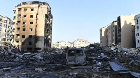
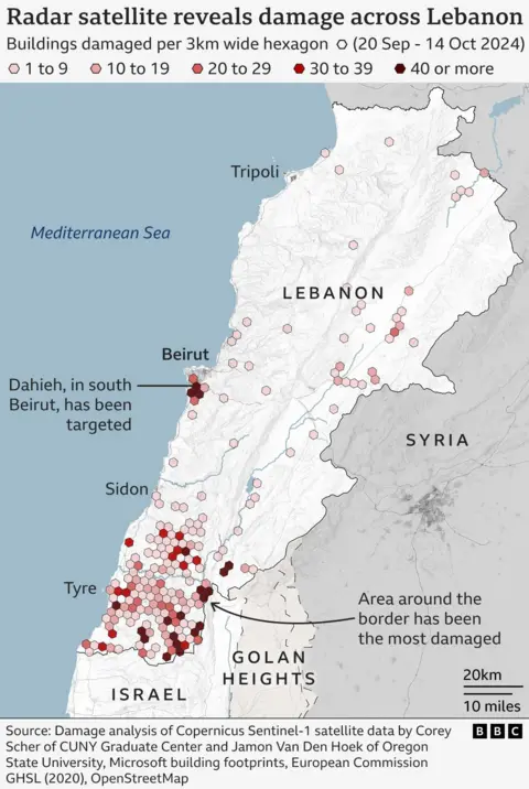
Israel’s intensified bombing campaign of Lebanon has caused more damage to buildings in two weeks than occurred during a year of cross-border fighting with Hezbollah, according to satellite-based radar data assessed by the BBC.
Data shows that more than 3,600 buildings in Lebanon appear to have been damaged or destroyed between 2 and 14 October 2024. This represents about 54% of the total estimated damage since cross-border hostilities between Israel and Hezbollah broke out just over a year ago.
The damage data was gathered by Corey Scher of City University of New York and Jamon Van Den Hoek of Oregon State University. They compared radar satellite images to reveal sudden changes in the height or structure of buildings which indicate damage.
Wim Zwijnenburg, an environmental expert from the Pax for Peace organisation, reviewed the satellite-based radar data and warned of the impact of Israel’s bombing.
“The Israeli military campaign seems to be creating a ‘dead zone’ in the south of Lebanon to drive out the population, and making it difficult for Hezbollah to re-establish positions, at the cost of the civilian population,” he said.

Cross-border hostilities between Israel and Hezbollah broke out after the armed Lebanese group started firing rockets in and around northern Israel in support of Palestinians on 8 October 2023, the day after its ally Hamas’s deadly attack on southern Israel.
Israel invaded southern Lebanon in a dramatic escalation on 30 September to destroy, it said, Hezbollah weapons and infrastructure in “limited, localised, targeted raids”.
Satellite photos, radar imagery, and military records show recent Israeli bombardment in Lebanon has focused on the southern border region. It has also expanded to central and northern areas, including the Bekaa Valley and Beirut’s southern suburbs.
The Israeli army said it hit thousands of Hezbollah targets across Lebanon, including the capital, Beirut.

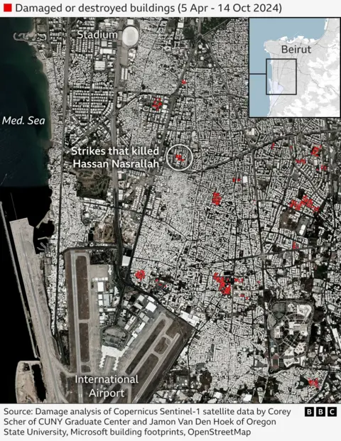
Most of the strikes on Beirut have targeted Dahieh, a southern suburb that is home to thousands of civilians. The Israeli military claims the area is home to Hezbollah’s command headquarters.
A series of Israeli strikes on buildings in the area killed Hezbollah’s leader Hassan Nasrallah on 27 September.
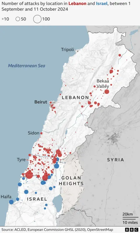
Separate data from the US-based Armed Conflict Location and Event Data Project (Acled), which has been analysed by the BBC, indicates at least 2,700 attacks by the Israeli military on Lebanese areas from 1 September until 11 October 2024. While these attacks primarily focus on southern border areas, they have also extended to northern and central regions.
Hezbollah has carried out around 540 attacks against Israel in the same timeframe, according to Acled. Each Hezbollah attack can include a barrage of rockets, missiles and drones.

The Israeli military says air strikes in Lebanon are targeting Hezbollah infrastructure.
It regularly adds it wants to ensure the safe return of tens of thousands of residents of Israeli border areas displaced by attacks from the Iran-backed group.
About 60,000 people have been evacuated from northern Israel because of near-daily attacks by Hezbollah. But some rockets have reached further south and damaged homes in and around the coastal city of Haifa.
On the Lebanese side, many Israeli air strikes targeted the city of Tyre, the Bekaa Valley, and Beirut, according to the BBC’s analysis of the latest monthly data collected by Acled.
Lebanon’s government says up to 1.3 million people have been internally displaced, whilst Prime Minister Najib Mikati warned of the “largest displacement” in the country’s history.
The Israel Defense Forces (IDF) has been issuing evacuation orders to residents across the country, including areas of Beirut.
In the south, the army instructed residents of several villages to leave their homes and “immediately head north of the Awali River,” which meets the coast about 50 km (30 miles) from the Israeli border.
“This is a humanitarian catastrophe,” Gabriel Karlsson, Middle East Manager at the British Red Cross in Beirut, told the BBC.
He said there are insufficient shelters to accommodate so many evacuees.
“I saw children sleeping in the streets,” Karlsson added, urging humanitarian organisations to coordinate their efforts to address the escalating crisis.
Lebanese officials say at least 2,350 have been killed and over 10,000 injured in Israeli attacks. The Lebanon health minister said many casualties were civilians.
On the Israeli side, 60 people have been killed and more than 570 wounded by Hezbollah attacks, Israeli authorities say.
“Collateral damage is inevitable in war”, Amos Yadlin, the former head of Israeli military intelligence, told the BBC.
The retired major-general blamed Hezbollah for the war and claimed Israel’s ground offensive would force the group out from the border areas.
Zwijnenburg, from the Pax for Peace organisation, however, has warned of the impact of Israel’s military campaign on civilians and the populated areas.
“The heavy blast radius kills and maims civilians nearby”, he said, in reference to Israeli air strikes.
“Open-source data combined with satellite imagery also showed that civilian infrastructure such as irrigation channels, gas stations and electricity grids were damaged, which is worsening the humanitarian situation,” he added.
Additional reporting by Paul Cusiac and Maria Rashed


