

BBC News Climate and Science

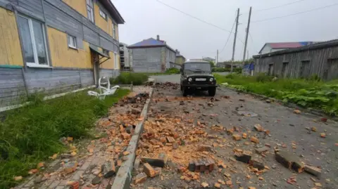 S. Lakamov/Anadolu/Getty Images
It has been one of the strongest earthquakes ever recorded – but so far has not brought the catastrophic tsunami that many feared.
When the 8.8-magnitude quake struck eastern Russia at 11:25 local time on Wednesday (00:25 BST), it raised concerns for coastal populations across the Pacific.
Millions of people were evacuated, as minds cast back to the devastating tsunami of Boxing Day 2004 in the Indian Ocean and Japan 2011, both triggered by similarly large earthquakes.
But today’s tsunami has been much less severe, even though it’s brought some damage.
So what caused the earthquake and tsunami – and why wasn’t it as bad as initially feared?
What causes a mega earthquake?
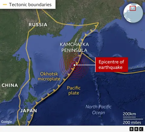
The Kamchatka Peninsula is remote but lies in the “Pacific Ring of Fire” – so called because of the high number of earthquakes and volcanoes that occur here.
The upper layers of the Earth are split into sections – tectonic plates – which are all moving relative to one another.
The “Pacific Ring of Fire” is an arc of these plates that extends around the Pacific. Eighty percent of the world’s earthquakes occur along the ring, according to the British Geological Survey.
Just off the coast of the Peninsula, the Pacific plate is moving north-west at about 8cm (3in) per year – only about twice the rate that your fingernails grow, but fast by tectonic standards.
There it comes into contact with another, smaller plate – called the Okhotsk microplate.
The Pacific plate is oceanic, which means it has dense rocks and wants to sink beneath the less dense microplate.
As the Pacific plate sinks towards the centre of the Earth, it heats up and begins to melt, effectively disappearing.
But this process is not always smooth. Often the plates can get stuck as they move past each other and the overriding plate is dragged downwards.
This friction can build up over thousands of years, but can then be suddenly released in just a couple of minutes.
This is known as a megathrust earthquake.
“When we typically think about earthquakes, we imagine an epicentre as a small point on a map. However, for such large earthquakes, the fault will have ruptured over many hundreds of kilometres,” explained Dr Stephen Hicks, lecturer in environmental seismology at University College London.
“It is this vast amount of slip and area of the fault that generates such a high earthquake magnitude.”
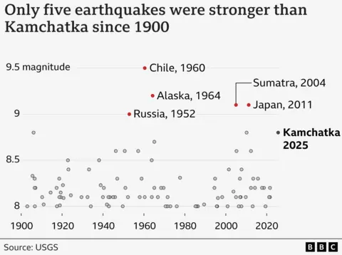
The largest earthquakes recorded in history, including the three strongest in Chile, Alaska and Sumatra, were all megathrust earthquakes.
And the Kamchatka Peninsula is prone to strong quakes.
In fact, another high magnitude 9.0 earthquake struck less than 30km (19mi) from today’s earthquake in 1952, the US Geological Survey says.
Why wasn’t this as bad as previous tsunamis?
This sudden movement can displace water above the plates, which can then travel to the coastline as tsunami.
In the deep ocean, tsunami can travel at more than 500mph (800km/h), about as fast as a passenger aeroplane.
Here, the distance between waves is very long and the waves aren’t very high – rarely more than a metre.
But as a tsunami enters shallow water near land, it slows down, often to about 20-30mph.
The distance between waves shortens, and waves grow in height, which can effectively create a wall of water near the coast.
But it’s by no means guaranteed that a very strong earthquake will lead to a particularly tall tsunami reaching far inland.
Today’s quake brought tsunami waves of 4m (13ft) in parts of eastern Russia, according to authorities there.
But they don’t come close to the waves tens-of-metres high of Boxing Day 2004 in the Indian Ocean and Japan 2011.
“The height of the tsunami wave is also affected by local shapes of the seafloor near the coast and the [shape] of the land where it arrives,” said Prof Lisa McNeill, professor of tectonics at the University of Southampton.
“These factors, along with how populated the coast is, affect how serious the impact is,” she added.
Initial reports from the US Geological Survey said that the earthquake was centred at quite a narrow depth, about 20.7km (12.9 miles) below the Earth’s surface.
That can lead to greater displacement of the seafloor, and therefore a bigger tsunami wave, but it’s hard to tell for sure so soon after the event.
“One possibility is that the tsunami models have maybe taken a conservative estimate on the earthquake depth,” Dr Hicks told BBC News.
“Potentially you could shift that earthquake another 20 kilometres deeper, and that would actually reduce the amplitude of the tsunami waves quite considerably.”
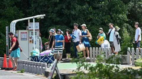 Philip FONG/AFP/Getty Images
Better early warning systems
Another important element is the development of early warning systems.
Due to the high occurrence of earthquakes in the Pacific region, many countries have tsunami centres. They send out warnings via public announcements for populations to evacuate.
No such system was in place when the 2004 Boxing Day tsunami occurred – leaving many people without time to evacuate.
More than 230,000 people died across 14 countries in the Indian Ocean.
Early warning systems are important because of the limited ability of scientists to predict when an earthquake will occur.
The US Geological Survey recorded an earthquake measuring 7.4 in the same region ten days before.
This may have been a foreshock – an early release of energy – but it is not a predictor of exact timing of a future earthquake, explained Prof McNeill.
“Although we can use how fast the plates are moving, GPS to measure current movements and when previous earthquakes occurred, we can only use this information to make forecasts of probability of an earthquake,” she said.
The Geophysical Survey of the Russian Academy of Sciences (GS RAS) will continue to monitor the region as it anticipates aftershocks could continue for the next month.


